Documentation
This page provides basic documentation. The dataset is documented in complete detail in the following publication:
De Soto, P., Pažout, A.,Brughmans, T. et al. (2025) Itiner-e: a high-resolution dataset of roads of the Roman Empire. Nature Scientific Data. https://doi.org/10.1038/s41597-025-06140-z
The road data has been collected by various contributors and is edited by a scholarly community. The method to create the data varies depending on the region and contributor but always tends to include three steps: (1) identifying roads based on existing scholarship including atlases, regional summary publications, survey reports, excavation reports, gazetteers and milestones; (2) localizing roads using modern and historical aerial and satellite photography and topographic maps; (3) digitizing roads and their metadata, and cleaning the data.
The method aims to digitize the exact position of each road segment by drawing on a large variety of available historical and archaeological data including:
- Published regional surveys, historical-geographical summaries and archaeological reports
- Milestone evidence and epigraphical databases (such as LIRE - Latin Inscriptions of Roman Empire)
- Ancient itineraries and cartographic documents (e.g. Tabula Peutingeriana)
- Modern and historical (19th/early 20th c.) topographical maps
- Modern and historical satellite imagery (e.g., Corona mission)
'Segm. Cert.' stands for segment certainty, and can be one of the following:
- 'Certain': well-documented segments in our sources that were digitised with high spatial accuracy (less than 50 m deviation in mountainous terrain, less than 200 m in the plains).
- 'Conjectured': segments with lower spatial accuracy due to lower level of documentation in our sources.
- 'Hypothetical': roads which are speculated to have existed in Antiquity but insufficient evidence exists to classify them as either 'Certain' or 'Conjectured', and roads in the desert areas where physical infrastructure of the roads was less fixed or where multiple parallel tracks might have existed.
'Const. per.' stands for construction period: Name of the magistrate or emperor during whose tenure the road was constructed, with exact dates in parenthesis.
'Type' can be either 'Main road' or 'Secondary road'. A road segment is defined as a 'Main Road' if it has more than one of these characteristics: a) presence of milestones, b) is part of an ancient Itinerary (chiefly the Antonine Itinerary and Tabula Peutingeriana), c) shares (a large part of) its course with a historically known major road indicated on 19th/early 20th century maps. The remaining roads were classified as 'Secondary Road'.
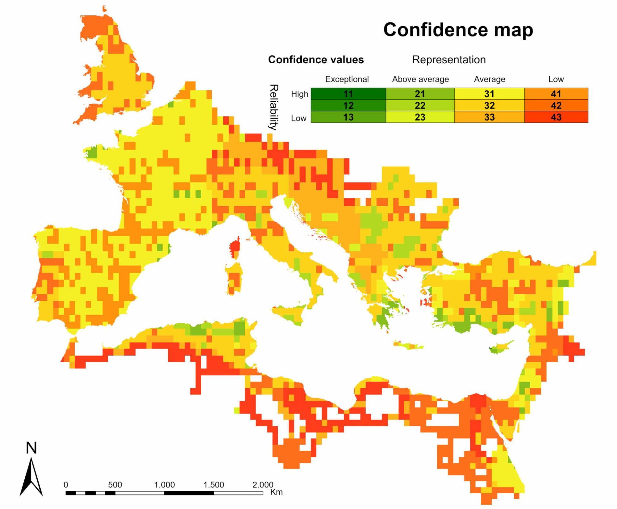
Confidence map
The reliability and completeness of our coverage of roads of the Roman Empire varies throughout the area for a number of reasons: some regions have received more published research efforts or are better described in historical sources than others; the contributors’ access to sources differed between regions; the preservation of physical traces of roads differ between regions.
This variability in reliability and completeness is visualized in this confidence map, for more details on its creation, see de Soto et al. (2025). This is why Itiner-e needs to be a living and growing resource, where corrections can be made and new findings about ancient roads are continually added to keep it the most up-to-date record. Itiner-e will serve as a platform for an open community of editors, and the next phase of development will include a process to join this community.
Bibliography
The sources used to digitize a road segment are listed in the 'Bibliography' field of each road segment. All bibliography entries can be found in this Zotero library.
'BAtlas X' refers to sheet X of the Barrington Atlas:
Talbert, R. J. A. (2000). Barrington Atlas of the Greek and Roman World. Princeton: Princeton University Press.
Pleiades places
The places shown on Itiner-e are downloaded and updated daily from the download section of pleiades.stoa.org. Their location is managed by Pleiades and not by Itiner-e. We only represent the following subset of Place Types from the full set of Pleiades Places: bridge, fort, major fort, major settlement, oasis, pass, port, settlement, station. Pleiades places in the vicinity of an Itiner-e route segment are linked to it in the downloaded GeoJSON LineString object via an additional property pleiadesPlaces.
Route-finding tool (beta)
Itiner-e allows you to create itineraries between ancient places, explore the time this took, and the different means of transport you could have taken. The current tool is a beta-version and is awaiting further development before we schedule a final release.
Learn how to use this tool on our tutorials page.
The tool calculates the shortest path over connected routes in the database between a pair of selected places. The distance in km of this path is shown as well as in hours of travel time.
Four modes of terrestrial transport can be selected, each with their respective travel speeds:
- Walking (
%20scale(0.100000,-0.100000)'%20fill='%23000000'%20stroke='none'%3e%3cpath%20d='M4084%2012786%20c-416%20-68%20-756%20-378%20-860%20-785%20-125%20-485%20105%20-988%20553%20-1210%20165%20-82%20277%20-106%20478%20-105%20139%201%20173%204%20257%2027%20363%2097%20649%20374%20752%20728%2075%20260%2051%20520%20-69%20764%20-139%20281%20-387%20483%20-690%20561%20-123%2031%20-301%2040%20-421%2020z'/%3e%3cpath%20d='M3765%2010455%20c-149%20-24%20-309%20-86%20-443%20-172%20-74%20-46%20-2133%20-1715%20-2202%20-1783%20-60%20-59%20-99%20-121%20-124%20-197%20-22%20-70%20-474%20-2108%20-482%20-2173%20-8%20-72%2015%20-180%2056%20-260%2087%20-172%20293%20-278%20483%20-249%2091%2014%20195%2068%20266%20140%2091%2091%20122%20163%20177%20409%2055%20250%20351%201598%20356%201623%202%2013%20738%20620%20745%20614%201%20-1%20-254%20-1134%20-567%20-2518%20l-568%20-2516%20-685%20-1150%20c-377%20-633%20-697%20-1177%20-710%20-1209%20-91%20-218%20-88%20-412%209%20-613%2038%20-78%2060%20-108%20132%20-181%2099%20-99%20186%20-152%20304%20-187%20250%20-72%20497%20-13%20689%20164%2033%2031%2080%2084%20103%20117%2081%20114%201517%202546%201576%202669%20l59%20122%20178%20823%20c97%20452%20180%20821%20184%20820%2012%20-6%201529%20-1669%201529%20-1677%200%20-16%20459%20-2425%20476%20-2496%2058%20-253%20250%20-466%20488%20-541%20330%20-104%20696%2050%20852%20358%2071%20140%2093%20324%2060%20499%20-8%2041%20-45%20233%20-81%20425%20-36%20192%20-115%20608%20-175%20924%20-60%20316%20-139%20733%20-175%20925%20-65%20345%20-95%20462%20-134%20526%20-11%2018%20-442%20532%20-958%201142%20-516%20609%20-937%201114%20-936%201120%208%2044%20475%202093%20478%202096%202%202%2096%20-181%20208%20-406%20158%20-315%20215%20-420%20251%20-460%2057%20-63%201612%20-1139%201711%20-1184%20189%20-85%20399%20-46%20539%20100%20173%20182%20179%20463%2013%20647%20-31%2035%20-269%20204%20-785%20560%20l-740%20509%20-145%20290%20c-643%201278%20-931%201841%20-966%201888%20-257%20349%20-656%20525%20-1046%20462z'/%3e%3c/g%3e%3c/svg%3e) 4 km/h)
4 km/h) - Ox cart (
 2 km/h)
 - Pack animal (
 4.5 km/h)
 - Horse courrier (
 6 km/h)
Speeds were informed by Carreras et al. 2019.
Major navigable rivers can be included in the route-finding (in preparation). The speeds are set at 2.5 km/h for downriver and 0.6 km/h for upriver, following Carreras et al. 2019. The navigable stretches of these rivers were calculated with a partially empirically validated algorithmic approach described in detail in this paper: Filet et al. (in preparation) Journal of Archaeological Science.
Major sea lanes and coastal sailing can be included in the route-finding (in preparation). The duration of travel relies on the work by David Gal using sailing software, iterated 5479 times per route, drawing on 15 years of weather data at an hourly resolution (2004-2018). The method is described in detail in Gal et al. (2022) ; and the raw data per sailing route is available at https://data.mendeley.com/datasets/hzbg2wyjxb/6.
In order to reflect friction of movement through the landscape we introduce a 'passability' multiplier into calculations of travel time in the routing tool. The 'passability' modifier is calculated as the proportion of speed on any given (positive) slope over speed on flat terrain (slope of 0°) using Tobler's hiking function. The resulting multiplier value (between 1-0.1) is then applied to the travel speed of the selected mode of transport (see above). It is applied only to slopes above 6%, to reflect the relative ease of movement on flat terrain compared to hilly and mountainous areas. The 'passability' is isotropic, disregarding direction of movement. Average slope of each road segment is calculated over 3-arc second resolution SRTM DEM.
How to cite Itiner-e
Citing the Itiner-e platform:
Brughmans, T., de Soto, P., Pažout, A. and Bjerregaard Vahlstrup, P., 2024 Itiner-e: the digital atlas of ancient roads. https://itiner-e.org/
The original static dataset should be cited as:
De Soto, P., Pažout, A.,Brughmans, T. et al. (2025) Itiner-e: a high-resolution dataset of roads of the Roman Empire. Nature Scientific Data. https://doi.org/10.1038/s41597-025-06140-z
Main contributors
- Project MINERVA
- Project Viator-e
- ERC Desert Networks Project
- Toon Bongers (Meuse and Scheldt basins)
- Joseph Lewis (Britannia and Sardinia)
- Michele Rüzgar Massa (Pamphylia)
- Giuseppina Renda (Campania)
- Hamdi Şahin (Rough Cilicia)
- Philip Verhagen (Dutch part of the Roman frontier)
- Barbora Weissova (Bithynia)